ENERGY.GOV | Office of Energy Efficiency & Renewable Energy Energy.gov Office of Energy Efficiency and Renewable Energy
WINDExchange
About WINDExchange
  • Types of Wind Energy
    • Types of Wind Energy
    • Distributed Wind
    • Land-Based
    • Offshore
    • What Is Wind Energy
  • Development & Impacts
    • Development & Impacts
    • Community Impacts
    • Economics & Incentives
    • Site Selection
    • Wind & Environmental Impacts
  • Guides, Maps, & Tools
    • Guides, Maps, & Tools
    • Guides
    • Maps & Data
    • Models & Tools
    • Publications
  • Education & Workforce Development
    • Education & Workforce Development
    • K-12 Resources & Curricula
    • Workforce Training & Education
  • More Tools & Resources
    • Maps & Data
    • Policies & Incentives
    • Publications
    • News & Events
  • Maps & Data
  • News & Events
  • Policies & Incentives
Wind Energy Technologies Office » WINDExchange » Guides, Maps, & Tools » Maps & Data
  • Guides
  • Maps & Data
  • Models & Tools
  • Publications

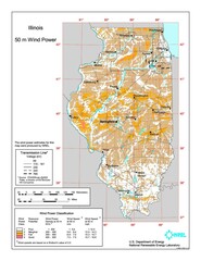
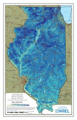
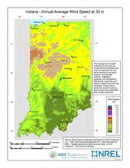
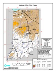
Wind Energy Maps and Data

Find maps and charts showing wind energy data and trends.

Filter by Turbine Hub Height

30-Meter
Residential
40-Meter
Wind Speed
50-Meter
Community
60-Meter
Wind Speed
100-Meter
Land-Based
100-Meter
Offshore
Also See: Data by State map of the United States
Tutorial: Understanding Wind Resource Maps link to wind map tutorial

Search by Keyword

156 results

Illinois 50-Meter Community-Scale Wind Resource Map

Illinois wind resource map.

Illinois Land-Based Wind Speed at 100 Meters

Last updated 3/19/2021

Indiana 30-Meter Residential-Scale Wind Resource Map

A map of Indiana showing wind speeds at a 30-m height.

Indiana 50-Meter Community-Scale Wind Resource Map

Indiana wind resource map.

Indiana Land-Based Wind Speed at 100 Meters

Last updated 12/22/2020

Iowa 30-Meter Residential-Scale Wind Resource Map

A map of Iowa showing wind speeds at a 30-m height.

Iowa Land-Based Wind Speed at 100 Meters

Last updated 3/30/2022

Kansas 30-Meter Residential-Scale Wind Resource Map

A map of Kansas showing wind speeds at a 30-m height.

Kansas 50-Meter Community-Scale Wind Resource Map

Kansas wind resource map.

Kansas Land-Based Wind Speed at 100 Meters

Last updated 3/30/2022

Kentucky 30-Meter Residential-Scale Wind Resource Map

A map of Kentucky showing wind speeds at a 30-m height.

Kentucky 50-Meter Community-Scale Wind Resource Map

Kentucky wind resource map.

Display results

  • ‹ Prev
  • 1
  • 2
  • 3
  • 4
  • 5
  • 6
  • 7
  • 8
  • 9
  • …
  • 13
  • Next ›
WINDExchange: U.S. Department of Energy

Sign up for our periodic newsletter

About WINDExchange
Technical Assistance
Models & Tools

WINDExchange is a resource of the U.S. Department of Energy's Wind Energy Technologies Office.

Contact Us | Wind Energy Technologies Office | Office of Energy Efficiency & Renewable Energy | Privacy